Behold The Majestic Mount Shasta!
With current circumstances making many unwilling to travel, I wanted to share a bit of “wanderlust”.
I drove from Los Angeles to Seattle recently, and some of the scenery on the way is truly incredible.
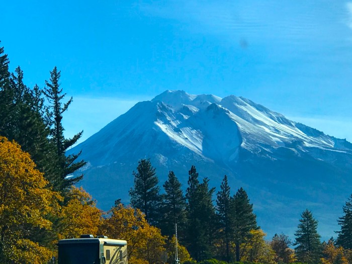
I was amazed once again by the spectacular Mt. Shasta – rising 14,179 feet above sea level!
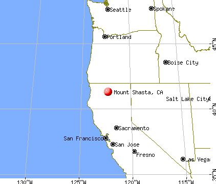
As you can see from this map, Mount Shasta sits at the southern end of the Cascade Mountain Range in Siskiyou County, California.
When you drive north on Interstate 5, the Mountain begins to peek out at you as you drive:

The mountain’s 14,179 feet elevation makes it the second-highest peak in the Cascade Mountain range. Mount Shasta has an estimated volume of 85 cubic miles, which makes it what they call the most “voluminous stratovolcano” in the Cascade Volcanic Arc. The mountain and surrounding area are part of the Shasta–Trinity National Forest.

Shasta Is A Sleeping Giant!
According to wikipedia, Mount Shasta erupts on average every 600 years!
The last significant eruption on Mount Shasta occurred about two centuries ago, so hopefully it will stay dormant.
However, Mt. Shasta’s neighbor to the north woke up forty years ago to deadly results:

May 18, 1980. (USGS)
In 1980, Washington’s Mount St. Helens, also located near Interstate 5 was the deadliest and most economically destructive volcanic event in U.S. history.
Fifty-seven people were killed; 250 homes were destroyed as well.

The cataclysmic eruption reduced the elevation of the mountain’s summit from 9,677 ft to 8,363 ft – yes, more than a thousand feet of mountain was turned to dust, leaving a horseshoe-shaped crater.
Climbing Mount Shasta!
These incredible mountains are for much more than just looking at while driving by!
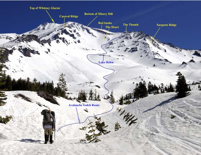
This chart shows the variety of ways you can climb to the top of Mt. Shasta – I’m not a climber, but if I was I’d get this view at the top!

The most popular route on Mount Shasta is Avalanche Gulch route, which begins at the Bunny Flat Trailhead and gains 7,300 feet of elevation during the approximately 11.5 mile round trip.

Mount Shasta was declared a National Natural Landmark in December 1976. The mountain and surrounding area are part of the Shasta–Trinity National Forest.
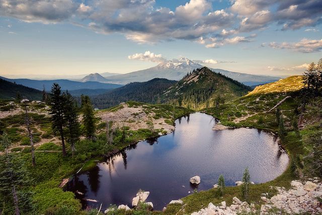
Hiking To Heart Lake!
I’d do the hike to this gorgeous – and well named – Heart Lake, where you can gaze upon Shasta’s timeless beauty.

I got shots going both north and southbound, which is why the mountain gave me several different looks – from one angle it looks like two separate peaks!

I didn’t get the chance stop to explore, but since you see the mountain from so many angles while driving, I got one last shot in my rear view mirror:

There are so many incredible things to see when driving through California…for example, we drove through this once:

Yes, my Prius fit, so I drove through the tree, and then we posed inside it as well…it’s one of the last remaining “drive-thru redwoods” left in California – a short-term gimmick thankfully only done briefly decades ago – check it out here:
https://johnrieber.com/2017/01/10/one-of-californias-last-drive-thru-redwoods-has-fallen/
Once past Mt. Shasta, you head north into Southern Oregon, which is incredibly beautiful as well:

Oh yes, you can pop over quickly to the Pacific Ocean and be wowed by the natural beauty of the Oregon Coast…here’s that trip we took as well:
If you like these stories, why not sign up to receive emails whenever I post? It’s easy to do, I do NOT collect any information about you at all, there are absolutely NO ads of any kind, just stories about movies, music, books, food, travel and pop culture…
You can sign up by clicking on my blog here and see the note on the right!
Let me know if you’ve seen Mt. Shasta, and don’t forget to sign up for daily updates!
Categories: Exotic Travel, Memoirs, nature, Travel, Travel Adventures, Travel Memoir

Gorgeous photos! This was really interesting, John.
LikeLiked by 1 person
Thank you for reading and commenting – I really appreciate it!
LikeLiked by 1 person
You are welcome, John!
LikeLiked by 1 person
Your photos make it hard to decide if mount Shasta is more beautiful in the winter or the summer… Both views look stunning! What prompted such a long road trip?
LikeLiked by 1 person
I think both are magical, right? I drove from Los Angeles to Seattle!
LikeLiked by 1 person
That’s quite the journey! How many days did it take?
LikeLike
It’s 19 hours from LA to Seattle, and I stopped 12 hours in…middle of Oregon…works well!
LikeLiked by 1 person
What would you say is the most beautiful stretch along that (long…. 🙂 ) drive?
LikeLiked by 1 person
Going past Mt. Shasta is one, the other is Southern Oregon through Grants Pass…absolutely gorgeous – but I always forget to get gas first, because for about 50 miles there isn’t much there!
LikeLike
Gorgeous country. We once drove from Vancouver, BC to California on a Honda Goldwing. What a great way to see the fabulous scenery.
LikeLiked by 1 person
Yes, that part of the country is incredibly green, right? Thanks for sharing!
LikeLike
Woah and what a trip!
LikeLiked by 1 person
It’s such a beautiful drive – that part of the country is spectacular!
LikeLiked by 1 person
I’ve never been, but intend to be there
LikeLiked by 1 person
What a fabulous travel post today, John! I’ve been to Shasta many times, usually a drunken houseboating weekend when younger. I’ll never see Heart Lake, so thank you.
LikeLiked by 1 person
A drunken house boating weekend sounds like a blast – thanks for the comment!
LikeLike
You do have some breathtaking scenery there, John. Thanks for that impressive tour. 🙂
Best wishes, Pete.
LikeLiked by 1 person
Mt Shasta is magnificent, and so is the hike to Heart Lake. I’ve lost count on how many times I’ve done that hike. It is equally beautiful every season.
LikeLike
Beautiful country and wonderful road trip!
LikeLiked by 1 person
Yes, with people pulling back on air travel, cruises etc you can still do a road trip and see incredible stuff!
LikeLiked by 1 person
Exactly! I see a road trip in my future this spring!
LikeLiked by 1 person